3-D reconstruction of 300 km of Vltava river
The presented article was written thanks to the inter-university cooperation between the Faculty of Civil Engineering of the CTU in Prague (Department of Geomatics) and the Faculty of Environment UJEP (Department of Geoinformatics – KGI). The main topic is the reconstruction of the original Vltava riverbed, which is being solved by the Faculty of Civil Engineering of the Czech Technical University within the framework of the project of the Ministry of Culture of the Czech Republic NAKI “Vltava – changes in the historical landscape due to floods, dam construction and changes in land use with links to cultural and social activities in the river surroundings”. KGI FŽP has long been involved in the reconstruction of vanished landscapes using geoinformatics methods. Thus, methodologies and datasets developed within the SGS project “Non-contact methods of spatial data collection as a tool for modelling and monitoring the human environment” were used in the article.
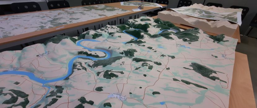
The paper presents a procedure for reconstructing the landscape that was flooded during the construction of the Vltava Cascade using archival data (old maps and aerial photographs). The reconstruction of the landscape using archival data has various pitfalls (e.g. regarding the accuracy of the data, or even the possibility to reconstruct the shape of the disappeared landscape from the data) – all this is shown in the article with the fact that old maps were used to reconstruct the section of the Vltava from its source to the confluence with the Berounka River (ca. 300 km). More than 23 thousand kilometres of contours were vectorised for the original elevation map, a digital relief model was created and the areas of the Lipno, Slapy and Orlik reservoirs were converted into real 3D landscape models with applied texture using CNC milling at the Department of Architecture of the Czech Technical University.
Link to the paper: J. Pacina, J. Cajthmal, D. Kratochvilova, J. Popelka, V. Dvorak, and T. Janata, Pred-dam valley reconstruction based on archival spatial data sources: Methods, accuracy, and 3D printing possibilities, Transactions in GIS (2021) – early view. https://doi.org/10.1111/tgis.12854