A Digital Replica of a Chemical Plant Can Save Lives
Transforming an entire industrial giant into virtual reality with such a level of detail that real-time crisis scenarios can be simulated is a technical rarity. This is exactly what Ing. Oto Weber from the Faculty of Environment at Jan Evangelista Purkyně University in Ústí nad Labem (UJEP) has achieved. His project attracted exceptional attention at the country’s largest geoinformatics conference and demonstrates how modern technologies can support crisis management.
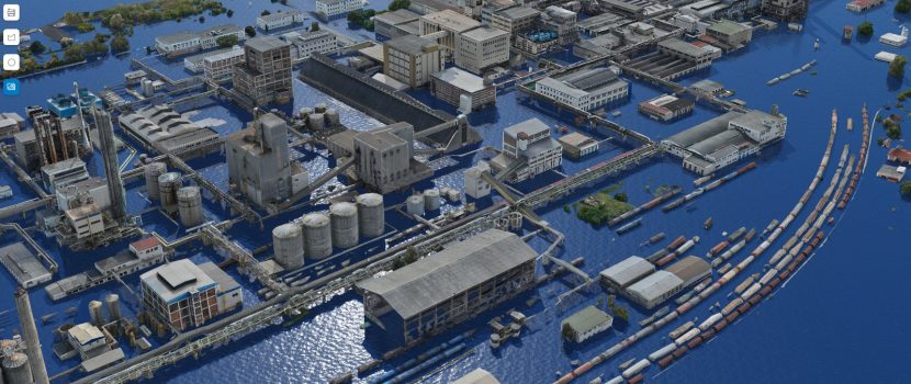
The digital twin is a precise replica of the Lovochemie industrial complex, created by combining state-of-the-art laser scanning (LiDAR) and photogrammetry. To produce such an extensive model, Oto Weber had to process an enormous volume of data and countless laser beam reflections.
A Technical Challenge
The project’s uniqueness lies primarily in the sheer amount of data and the demanding computational requirements. “Normally, models of this level of detail are created for individual objects. We decided to tackle the entire site, which represents an exceptionally large dataset that pushes the limits of standard hardware,” explains doc. Jan Pacina from the Faculty of Environment at UJEP, the guarantor of the study programme and supervisor of the thesis.
Processing tens of thousands of photographs and point clouds required the simultaneous use of ten of the faculty’s most powerful computers. “We had to distribute the computations so that tasks could be processed in parallel and the results delivered within a reasonable time,” Pacina adds. The faculty’s cutting-edge technical infrastructure—recently upgraded with an even more powerful computing server—made it possible for the student to push the boundaries of what is feasible within a master’s thesis.
The Model as the Heart of Crisis Management
The result is publicly available in a web application that runs directly in a browser.
“I wanted the outcome to be more than just a static image—it needed to be a functional tool. It allows crisis management teams to model, in real time, for example, the spread of flooding across the site, analyze the fields of view of security cameras, or monitor the number of people inside buildings,” explains project author Oto Weber.
In the event of a real accident, this tool could determine the speed and effectiveness of emergency response operations. It significantly reduces risks not only for employees but also for the surrounding environment of the chemical plant.
Data collection within an active chemical facility was a logistical challenge. In addition to drone permits, movements on the railway siding had to be coordinated, and company firefighters supervised flight safety. The project was supported by the company ArcDATA PRAHA.
Success Among the Elite
The project’s exceptional quality was also confirmed by its success at the GIS Esri Conference in Prague. Oto Weber advanced to the finals of the prestigious Student GIS Talent 2025 competition, and his presentation ranked among the highlights of the user section. He also received an award from the North Bohemian branch of the Czech Geographical Society.
Weber has additionally published his work on the GitHub platform. “I want it to serve as a foundation for other developers or students. Modern geoinformatics should not stay locked away in a drawer,” concludes the award-winning graduate.
The digital twin of the Lovochemie complex is available online at:
https://clefdevoute.github.io/SafetySphere_app/
The purchase of the computing server was implemented within the RUR – Region to the University, University to the Region project, registration no. CZ.10.02.01/00/22_002/0000210.